










This summer has served as a grim preview of a changing climate. From catastrophic flash flooding in the Grand Canyon to the terrifying sight of hurricanes encroaching on Hawaii, the United States has been gripped by a relentless series of extreme weather events. While the public looks for immediate causes, the scientific community is pointing toward a massive, developing force in the Pacific Ocean: a "Super El Niño" of unprecedented proportions.
Meteorologists and climatologists are now warning that this is not merely a seasonal anomaly. The current weather patterns, intensified by this gargantuan climate driver, may continue to exert a volatile influence on global systems well into 2027.
The Anatomy of a Super El Niño
At its core, an El Niño is a periodic climate pattern characterized by the warming of surface waters in the Eastern Tropical Pacific Ocean. In a "neutral" year, the warmest water is typically sequestered in the Western Pacific subsurface. Over several years, heat accumulates in that region. When specific wind patterns weaken, this vast reservoir of warm water "sloshes" eastward across the Pacific basin.
"It causes a form of climate chaos around the globe because of this distribution of heat being shifted from the Western Pacific into the Eastern Pacific," explains Jeff Berardelli, Chief Meteorologist at WFLA-TV. "And this one is a big one—the largest we have ever seen by a long shot."
While El Niño events are natural, the current iteration is being supercharged by the anthropogenic warming of the world’s oceans. Approximately 90% of the excess heat generated by global carbon emissions is absorbed by the ocean. This stored energy is now feeding into the current El Niño, creating temperature anomalies that defy historical precedent.
Chronology of an Escalating Crisis
The emergence of this record-breaking weather event did not happen in a vacuum. Its progression follows a trajectory that has been monitored by satellite data and climate modeling for months:
- Pre-Development Phase: Over the last several years, the Western Pacific accumulated record-breaking levels of subsurface heat. Climatologists identified the potential for a significant shift as trade winds began to show signs of instability.
- The Onset: By early spring, ocean temperature sensors indicated that the "slosh" had begun. Surface temperatures in the Eastern Pacific began rising at a rate that outpaced previous major El Niño events, such as the historic 1997-1998 and 2015-2016 cycles.
- Mid-Year Acceleration: By summer, the anomaly reached a critical threshold. Current models indicate the Eastern Pacific is on track to hit a temperature anomaly of approximately four degrees Celsius. To put this in perspective, the previous historical record was 2.8 degrees Celsius. This leap is not merely incremental; it is statistically staggering.
- The Current Outlook: As we move through the remainder of the year, the "east-based" nature of this El Niño—where the warming is concentrated in the Eastern Pacific—ensures that the continental United States will bear the brunt of the atmospheric instability. Experts warn that the ripple effects of this heat redistribution will likely dictate global weather patterns for the next two to three years.
Supporting Data: Why This Cycle is Different
The technical data behind the current El Niño suggests we are in uncharted territory. The primary indicator is the sheer volume of thermal energy.
The Temperature Anomaly Gap
In previous Super El Niño events, scientists looked for anomalies in the range of 2.5 to 3 degrees Celsius above the long-term average. The current trajectory toward a 4-degree anomaly represents a massive surge in energy. This excess heat is not just a number on a graph; it serves as a massive fuel source for atmospheric instability.
Wind Shear and Storm Dynamics
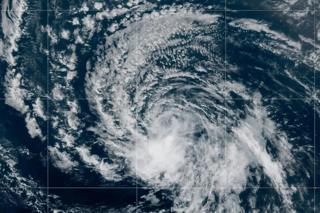
The influence of this event is already visible in the disparate hurricane activity between the Pacific and Atlantic basins. In the Pacific, the warm water is fueling major, intense hurricanes at a rapid rate. Conversely, the Atlantic is seeing a different phenomenon: while the ocean surface is warm, high levels of wind shear—a side effect of the atmospheric circulation caused by the Pacific El Niño—are tearing apart developing storms before they can strengthen. This creates a "feast or famine" dynamic for hurricane development that complicates disaster preparedness.
Official Responses and Scientific Consensus
The scientific community is largely in agreement: the convergence of a natural El Niño with long-term global warming has created a "compounding effect." However, there is ongoing debate regarding the exact degree to which climate change amplifies these events.
Recent studies suggest that global warming may be making El Niño events more frequent and more intense. The logic is simple: if the baseline temperature of the entire ocean is higher, the "fuel" available for any given climate event is inherently higher.
"All the oceans are warming, and the way that we determine the impacts of El Niño is based on the heat in the Eastern Pacific relative to the rest of the world’s oceans," Berardelli notes. "While the Eastern Pacific is record-hot, the rest of the ocean is also record-hot. This creates a complex feedback loop that scientists are still working to fully understand."
Implications: What to Expect Through 2027
As the U.S. heads into the coming seasons, the meteorological outlook is both specific and concerning. The "east-based" nature of this El Niño suggests that the Southern United States, particularly Florida and the Gulf Coast, should prepare for a wetter-than-average period.
Increased Severe Weather Risks
Residents across the Southeast can expect more frequent and potentially more severe weather outbreaks. The combination of increased moisture and atmospheric instability creates a recipe for significant storm systems, including heightened risks of tornadoes and flash flooding.
The California Outlook
For the Western United States, particularly California, the forecast points toward a potentially rainy winter. While this could provide a reprieve from long-term drought conditions, it also brings the risk of severe flooding, landslides, and infrastructure strain.
Thermal Trends: Cooler but Not "Cold"
In the southern tier of the country, the prevalence of cloud cover and increased precipitation is expected to keep temperatures lower than they would be on a typical sunny, dry day. However, this does not equate to "cold" weather in the traditional sense. Climatologists are not anticipating major, prolonged cold-air outbreaks. Instead, the country may experience a "damp-cool" winter, while the northern states and the Great Lakes are expected to see warmer-than-average temperatures, making heavy snowfall more difficult to achieve.
The Long Road Ahead
The warning from meteorologists is clear: the climate is currently undergoing a structural shift. The persistence of these effects through 2027 highlights the reality that we are no longer dealing with short-term seasonal fluctuations, but rather a long-term adjustment to a new, higher-energy global baseline.
For policymakers, infrastructure planners, and the public, the message is one of resilience. With the knowledge that these supercharged patterns are likely to repeat and persist, the focus must shift from reactive disaster management to proactive adaptation. As the oceans continue to store and release this unprecedented amount of heat, the global community must prepare for a future where "extreme" is the new normal.
The data is in, the models are clear, and the atmosphere is reacting accordingly. The Super El Niño is not just a weather event—it is a harbinger of the atmospheric volatility that will define the coming years.